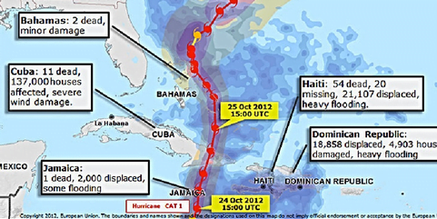
Americans are understandably focused on the massive damage caused by superstorm Sandy in New York and New Jersey. This map is a useful reminder that Sandy left a VERY long trail of destruction, beginning in the Caribbean.
Facts and figures from SuperStorm Sandy, via the UN’s Office for the Coordination of Humanitarian Affairs:
The eye of Hurricane Sandy made landfall near Kingston on Jamaica on 24 Oct 2012 and struck Cuba the next day.
In Cuba, approximately 15,000 homes were destroyed and 75,000 people were left homeless and are living with relatives or in communal shelters. An additional 43,000 homes were damaged and 80 per cent of water systems impacted.
In Jamaica, 1,500 families were affected, and 40-60 per cent of houses have roof damage and all crops affected in the hardest hit areas in the north/north west.
In the Dominican Republic, 17,530 persons have been displaced, 580 persons housed in official shelters, 3,506 houses were flooded, 56 houses were severely damaged, and 7 houses were destroyed.
In the Bahamas, damage knocked out power lines and created a pile-up of debris, and there was significant loss of livelihoods with crops and fishermen affected.
In Haiti, up to 17,187 people were evacuated to 118 emergency shelters including those living in 12 highly vulnerable camps. Some 5,981 families were affected (roughly 29,900 people). In addition 1,811 houses were flooded, 2,089 damaged and 1,885 destroyed. (IFRC, 30 Oct 2012)
In the United States and Canada, 43 people were killed as a result of the storm, and hundreds of thousands of residents from New England to North Carolina were ordered to evacuate their homes and seek shelter (AFP, 31 Oct 2012).